 1. Digitally Preserving Fort Conger.
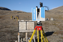
Fort Conger is a polar heritage site of national and international significance. The site is located in Quttinirpaaq National Park, on northeastern Ellesmere Island. The site was digitally preserved by team members Chris Tucker and Peter Dawson in 2010, through partnerships with Parks Canada and CyArk, an organization dedicated to digitally preserving world heritage at risk. The site is associated with several important polar expeditions, including the British Arctic Expedition (1875-76); the Lady Franklin Bay Expedition (1881-84) and Robert Peary's expeditions to reach the North Pole (1899,1905,1908). The entire site was scanned in 2010, using a Z+F imager 5006i scanner. Among the cultural features captured were the remains of the Lady Franklin Bay Expedition house, and the three standing structures associated with Robert Peary's hut complex. The digital data was donated to CyArk's digital heritage archive in 2013. Plans are to return to Fort Conger and rescan the site. Change detection analysis will then be used to compare the point cloud data from 2010 with new data, allowing us to better understand the impacts of climate change processes and human activity at this important polar heritage site.
2. Science and Survival at Fort Conger - a Virtual Heritage Exhibit.
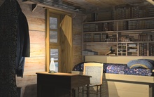
This project explores the role that computer reconstruction can play in mobilizing knowledge about polar heritage sites and their significance to the general public. Funding through the Virtual Museum of Canada's Virtual Exhibit's program was used to reconstruct the cultural landscape of Fort Conger, as it would have appeared at different points in its history. Computer reconstructions of expedition ships, as well as the Lady Franklin Bay Expedition House, and Robert Peary's hut complex, created many challenges relating to authenticity and historical accuracy in light of limited data. Games were also designed which simulate the scientific experiments carried out by expedition members as part of the First International Polar Year (1882-83). Future research will focus on understanding the degree to which the values and meanings associated with actual heritage sites are transferred to their digital replicas. A link to the site can be found in the Digital Heritage Websites section of this site.
 3. Arctic CHAR: Arctic Cultural Heritage at Risk.
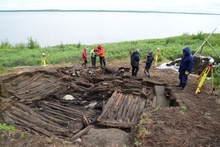
Many indigenous heritage sites in the Western Arctic are at risk due to the impacts of erosion caused by storm surges and thawing permafrost. My role in this project, which is lead by Dr. Max Friesen, University of Toronto, is to assess the potential of terrestrial laser scanning as a tool for documenting and monitoring heritage resources at Kuukpak, a pre-contact Inuvialuit village on the east channel of the Mackenzie river. Geomatics engineering graduate student Adam Jahraus scanned one of the largest Inuvialuit sod houses ever excavated during the 2014 field season. An error model will be used to assess the potential of laser scanning as a site monitoring and computer reconstruction too. Collaborators on this project are Dawson, Jahraus, as well as Dr. Derek Lichti, Geomatics Engineering, University of Calgary.
 4. Using Photospheres to Document Arvia'juaq National Historic Site.
Arvia’juaq is a small coastal island located near the community of Arviat. It was declared a National Historic Site in 1995 because of its central importance to the Paatlirmiut Inuit who live in the Arviat area and Maguse river drainage. Parks Canada and the Arviat Historical Society have carried out detailed oral history and place name work at Arvia’juaq. In 2015, Dawson and collaborators Darren Keith (Kitikmeot Heritag Society); Luke Suluk (Department of Education, GN); Denis Gadbois (Department of Art) and Colleen Hughes (graduate student) used drone-mounted aerial cameras to capture the most significant features at the site, including:
a. Qillalugaujarvik – Beluga Kayak game. This feature consists of the stone outlines of ten kayaks, behind which lie six piles of rocks that may symbolize hunter’s base camps. Oral histories indicate that children and adults would sit in the kayaks and try to spear a loop of baleen, as it was dragged around the outlines.
b. Nallujarvitt – Caribou Crossing Game. This feature is comprised of two long parallel lines of rocks, which according to Paatlirmiut oral history are meant to represent the edges of a caribou river crossing. In one version of the game, people imitating caribou would attempt to cross the river while avoiding others acting as hunters. In another version, individuals would line up along the long rows of rocks and try to spear a tiny hoop attached to a thick rope, as it was dragged along the inside of the stone feature.
c. Kattuajaq – Shaman’s Healing Stone. This rock cairn is comprised of two stone walls approximately one-half meter apart. Oral histories explain that a sick person was made to crawl through the rock structure and, if they made it safely to the other side, were expected to fully recover from their illness.
d. Tunnillarvik – Offering Cairns/Places. These stone cairns were places where visitors made offerings to promote a sense of well-being when confronted with problems such as resource shortages, or inter-personal conflicts. Offerings and gestures made at these cairns, which are scattered across the island, were believed to ensure good fortune when times were bad.
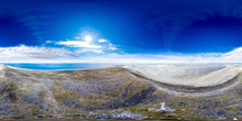
Denis Gadbois is currently using advanced methods to create photospheres that will enable users to virtually experience Arvia'juaq by looking up, down and around in 360 degrees.
Click on Image to see an examples of photospheres completed by Denis Gadbois.
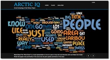 5. Arctic IQ: A Web-Based Tool for "Crowd Sourcing" Traditional Inuit Knowledge
Arctic IQ is a web based app that allows Inuit knowledge holders to add, edit and delete traditional place names using interactive Google-Earth like map sheets. The website currently contains over one thousand place names covering many areas of the Kivalliq District of Nunavut. The data was collected over a period of seven years with the aid of Inuit Elders Mark Kalluak, Louis Angalik, and Donald Uluadluak. Joe Karetak also played a large role in this project through translation and the contribution of knowledge. Current research is focused on using natural language processing algorithms (sentiment analysis) to measure emotional attachment to place, and "crowdsourcing" images of named places via Inuit hunters. Collaborators on this project include Kenneth Buck (web design); Natasha Lyons; and Colleen Hughes. Darren Keith and Luke Suluk have helped a great deal with translations and revisions of place names. A link to the Arctic IQ website can be found in the Digital Heritage Websites section.
Click on Image to visit the Arctic IQ website.
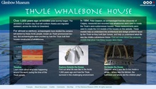 6. The Thule whalebone House.
This virtual exhibit was done in partnership with the Glenbow Museum and the Virtual Museum of Canada. Computer reconstructions of a distinctive house type, built using the bones of large baleen whales, are used to explore Thule Inuit culture. The Thule are the cultural and biological ancestors of contemporary Inuit. The virtual whalebone house is filled with artifacts that were digitized using actual objects from the Glenbow Museum's collection. The virtual exhibit was created in 2009. The virtual reconstruction of the whalebone house is based on archaeological data from the Deblicquy site, located on Bathurst island, in the Canadian High Arctic. The model has since been used as a virtual laboratory for exploring Thule construction practices, as well as the impact of lighting on the organization of domestic space. See the Publications section for articles on this research, as well as the Digital Heritage Websites section for links to the website.
Click on Image to visit the Thule Whalebone House Website.
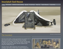 7. The Inuvialuit Sod House.
Like the Thule whalebone house, this virtual exhibit uses a computer reconstruction of an Inuvialuit Whalebone house to explore Inuit culture in the western Canadian Arctic. The site was built in 2010 and used as VirTools plug in to create a game-like experience allowing the user to move about inside and outside the house. In each of these virtual worlds, animated artifacts such as bow drills, drums, and ulus demonstrated the domestic activities of Inuvialuit families. An Inuvialuit Elder provided voice overs in both English and Inuvialuktun. Plans are to update the site, however, most of the content is still accessible. Collaborators include Dr. Richard Levy, Dr. Charles Arnold, and Natasha Lyons. You can access this site through the Digital Heritage Websites section.
Click on Image to visit the Inuvialuit Sod House Website.


